Iceberg in Greenland 2013 (SEILfoto: Jan Fr. Mack)
The ability to predict the weather has been central to seamanship as long has man has sailed the oceans.
This weather page has two sections:
-
Introduction to formats and equipment used for weather planning and forecasts
-
Or go directly to links and frequencies related to forecasts
There is a huge amount of literature about weather and weather phenomena, on how to predict, and on how to handle the boat in rough weather.
A surprising number of sailing boats circumnavigate without ever hitting severe weather. This is largely thanks to knowledge about sailing routes and seasons, and because of the availability of early and good forecasts.
Introduction: Use of various formats and equipment
A typical long distance cruising boat can download forecasts all over the globe using standard communications equipment. The formats used are discussed below. Only pilot charts need to be purchased/downloaded before you go. Equipment used:
- Local radio, FM, AM or DAB
- VHF
- 3/4G, GSM (NMT) in combination with PC (apps, mail, web)
- Navtex
- HF radio/SSB (single sideband) in combination with PC or (world wide)
- Inmarsat (world wide to approx. 70 degrees N/S – from phone/mail to web)
- Iridium (truly world wide) or other brand Sat-phone in combination with PC to dowload weather data(information
- inReach or Yellowbrick can be used to obtain limited forecasts when paired with other device (ios or android)
Types of weather information:
1. Pilot Charts
Used for planning, pilot charts answer questions like: What wind and currents can I typically expect sailing from A to B in a given month? Roughly when should I plan to sail, and what is the best route?
The charts give a graphical presentation of statistical data for wind and currents. There is typically one chart for each sea area per month.
The validity of Pilot Charts is being discussed in view of fairly rapid climate change. E.g. will they give the correct timing of the monsoon seasons? Are wind patterns changing?
American pilot charts are public domain and can be downloaded free of charge in PDF format: http://www.offshoreblue.com/navigation/pilot-charts.php
Jimmy Cornell can offer charts based on what are possibly more current data from American satellites. These can be bought from http://www.cornellsailing.com/buy-cornell-books-ebooks/jimmy-ivan-cornell-ocean-atlas-pilot-charts-routeing/
Note that pilot charts will not reflect special phenomenon like el Nino or la Ninja.
2. GMDSS (Global Maritime Distress and Safety System)
…provides forecasts as text or on radio. They can also be picked up by Navtex, Inmarsat or by e-mail (Sailmail , Winlink , services like MailASail) or simply from web pages. These represent the best interpretation of weather data available, and they are particularly useful close to the coast. Forecasts are also available by Iridium based "tracking devices" like inReach and Yellow Brick. The main sources can be found in section 2.
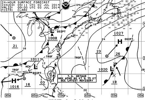
Example from NOAA:
FZNT23 KWNM 020423 OFFN01 NAVTEX MARINE FORECAST FOR NE US WATERS NWS OCEAN PREDICTION CENTER WASHINGTON DC 1223 AM EDT WED JUL 2 2014 CONDITIONS GIVEN REPRESENT THE HIGHEST WITHIN THAT PERIOD. ...PLEASE REFER TO COASTAL WATERS FORECASTS (CWF) AVAILABLE THROUGH NOAA WEATHER RADIO AND OTHER MEANS FOR DETAILED COASTAL WATERS FORECASTS... .SYNOPSIS...A COLD FRONT WILL SLOWLY APPROACH FROM THE NW TONIGHT THROUGH THU NIGHT...THEN STALL NEAR THE COAST FRI. TROPICAL STORM ARTHUR CURRENTLY JUST OFF THE E COAST OF FLORIDA WILL TRACK N ......
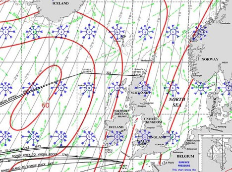
3. Synoptic Charts
The traditional weather charts are typically issued as surface analysis (now) and 12, 48, 72 and 96 hours or even further into the future. These charts give a good overview of the weather, but wind force and direction must be estimated or calculated based on the isobars. For sailors they are particularly useful in the way the show fronts which can give locally high winds and sudden changes. This information is not explicit in the GRIB files. Cruisers may find the synoptic charts a very good supplement to the GRIBs.
Less commonly used are the 500millibar charts that describe the
weather high up in the atmosphere. The 500millibar is frequently called
the “steering level” since the lows up here typically influence the
movement of lows down below. These charts may be most useful in the
westerlies or the high north. If there is a good correspondence between
surface and 500mb this may be an indication of a more stable/trustworthy
forecast when the lows penetrate to high up in the atmosphere.
See Unisys Weather.
Also the 300millibar charts may give interesting information. These are typically used to show the "jet streams", the fast moving air high up in the atmosphere. In a sailing perspective they may help predict the formation of troughs and ridges and may help in long term forcasting.
If you want to learn more see theweatherprediction & charts
Synoptic charts may typically be downloaded as “weather fax” by HF/SSB radio using Sailmail or Winlink. They will also be available from many web pages run by national weather services, notably by the American NOAA (see below). You can download an extensive schedule for Weather Faxes here.
The App HF Fax for iPad and Google Play will interpret weather faxes directly from the speaker of an SSB radio.
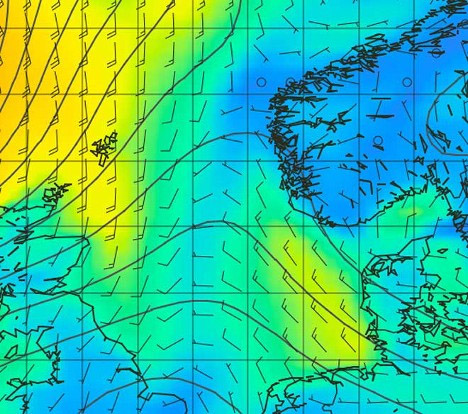
4. GRIB files (GRidded Information in Binary)
These are possibly the most important weather tools for long distance cruising at sea. They are entirely based on mathematical/numerical models. These models are the basis for all modern forecasting, but in GRIB files they are untouched by the meteorologists. Global information about pressure, temperature, wind etc. is loaded into the database giving a prediction with isobars, wind, cloud cover and precipitation for every 3 hours up to seven days into the future.
There are a number of models, of which GSF (Global Forecast System) is the most commonly used. Other models include NOGAPS (Navy Operational Global Atmospheric Prediction System). Lately the European ECMWF has been considered the most accurate. The models are continuously evaluated and tweaked. How good are they?
My own experience is that they are very good well clear of the coast (sometimes you need to be quite far away from the coast, but this is likely to improve as the models become better). Out at sea they are likely to be quite accurate two to three days into the future, useful up to five. Seven days may be useful if you are able to correlate with other data. So far fronts are not shown which may be due to the rather coarse grid used for the calculations (typically .5 degrees).
There are a number of sources for GRIB files:
Sailmail (maritime) and Winlink (HAM radio) will both deliver various types of GRIB files provided by Saildocs. Sailmail og Winlink has e-mail services via SSB radio, but can also be used via web or Iridium sat-phone. The files are mainly intended as overlays for charting software.
There is also a number of dedicated services that provide weather forecasts, the most common is MailASail.
Grib.us (Ugrib -> Windows) or zyGRIB are dedicated PC programs that present GRIB files online.
iGRIB for iPad and Android surfboards or smartphones – see iStore and Google Play.
PassageWeather and many others via the web
More sources can be found in section 2.
Independent of media and format, it is important to remember that a forecast is not weather. Increasingly convincing forecasts sometimes can make you forget that local conditions may far exceed the forecast. The effect of local squalls will not be shown on the GRIB files.
MailASails web pages with Frank Singleton and Chris Tibbs give a very good overview of weather and forecasts for cruisers.
There are a large number of web based services that offer Grib files together with analysis tools. As an example PredictWind offers online weather routing.
Personal weather routing
....seems to be increasingly popular. With good communication equipment they offer tailor made professional help. Personally I still think it is very beneficial to have at least rudementary understanding of weather systems and forcasting. Good options for paid weather routing:
Hyperlinks
Progress is fast. New systems go online frequently. Please report back to jfm(at)sailaway.no
Scandinavian and Baltic:
Vaderkortet (weather card) Baltic and Scandinavian FM radios and VHF Weather forecast schedules in Swedish. Weather is mostly in local - in English on demand. 24/7 watch on working channels
Norwegian DAB radio sends contineous costal forecasts at "NRK vær" (in Norwegian)
Yr Norwegian online forecasts including wind chart at sea. You can enlarge chart and choose English. You can zom and pan. (very detailed).
Theyr Icelandic online forecasts - easy to use animation (English, German, French)
DMI The Danish weather service - good online charts with emphasis on Greenland and the Faroes.
SMHI The Swedish weather service in Swedish and English
VHF Norwegian VHF working channels (see local channel plans with times for Securite and Weather) Weather is mostly in local languange at designated times - in English on demand. 24/7 watch on working channels
Web - World Wide forecasts:
PredictWind: Grib with routing function, also with app for ios, os-x and Android
Windyty: Grib with good visualisation - free
Sailing Weather Online Good, easy to use for the Atlantic including GRIB and Synoptic charts from Bracknell
Ugrib: Very good Internet based program for GRIB files on PC.
Free - not Mac
zyGRIB Internet based GRIB files for Mac
Windfinder Local forecasts for kites, surfers and boating
PassageWeather Webbased GRIB, very popular. Lacking in resolution in many sea areas
USA`s weatherservice NOAA, Outstanding World-wide weather service online including weather fax and hurricane/typhoon forecasts
Wetterzentrale German overview of alternative weatherfax sources
Weather Online Online, World-wide easy to use British forecasts
Extreme overviews Global weather
ios, Android World Wide:
iGrib: Good App for GRIB files for ios and Android - free
PredictWind: Apps for ios and Android
HF, Iridium, Inmarsat:
Sailmail Global e-mail and weather forecast system for SSB
(maritime), iridium and Internet
Winlink Global e-mail and weather forecast system for SSB
(HAM), iridium and Internet
Weather Faxes World Wide schedule from NOAA
MailASail Equipment and service deliveres GRIB, Synoptic, Text
HF
Fax:
App for reading Weather Fax directly from the SSB
loudspeaker, iPad and Android
Navtex Pad Weather Interprets Navtex messages from HF radio on iPad, see overview
Buoy Weather Much used forecasts for specific buoy position (pay) online and e-mail
PredictWind: "App" for Mac OS-X - Grib with routing function
Special areas:
British Met Office Marine Good maritime weather forecasts for area Iceland - Norway – Spaine, various formats
New Zealand and the Pacific Good for New Zealand og Tasman Sea,
good overview.
New Zealand`s weather service Goode pages - App for NZ local weather
Australia`s weather service Useful weather forecasts in Australian waters
Seabreeze Australian local, coastal wind
Fiji`s weather service Local weather forecasts for Fiji and the Fiji archipelago
Philippine weather service Local weather forecasts for the Philippines
Typhoon 2000 Philippine typhoon forecasts
Japanese maritime Good forecasts for Japan in English
Japansk typhoon forecast
Solmate lokal Mex West Coast Mexico and local for Baja California
Ice forecasts:
Notation for Ice forecasts: Danish Canadian Baltic
the Baltics and here